Geographic Information Jordan is a Middle Eastern country, bordered by Syria to the north, Iraq to the northeast, Saudi Arabia to the east and south and Israel and West Bank to the west. All these border lines add up to 1619 km. The Gulf of Aqaba and the Dead Sea also touch the country, and thus Jordan has a coastline of 26 km.Jordan consists mostly of arid desert plateau in the east, with Highland area in the west. The Great Rift Valley of the Jordan River separates Jordan and Israel. The highest point in the country is Jabal Ram, while the lowest is the Dead Sea. Along with 14 other countries, Jordan is considered to be the “cradle of humanity”.Major cities include the capital Amman in the northwest, Irbid and Az Zarqa, both in the north.The climate in Jordan is dry and hot, since the country is mainly desert. However, the country receives some rainy season in the west from November to April.
Map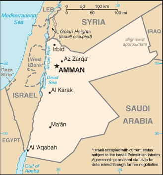
Location: Middle East, northwest of Saudi Arabia
Total borders: 2,197 km
Border countries: Iraq 181 km, Israel 238 km, Saudi Arabia 744 km, Syria 375 km, West Bank 97 km
Coastline: 26 km
Terrain: mostly desert plateau in east, highland area in west; Great Rift Valley separates East and West Banks of the Jordan River
Elevation extremes
lowest point: Dead Sea -408 m highest point: Jabal Ram 1,734 m
Climate: mostly arid desert; rainy season in west (November to April)
Tourist Season: June through December
Peak Tourist Season: June through August
Waters: Dead Sea, Gulf of Aqabah, Jordan River
Natural hazards: droughts; periodic earthquakes